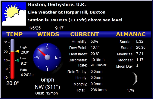
Current Local Weather Conditions in Buxton, Derbyshire, UK - Updated Every 5 minutes
For Local People, Visitors, Hill Walkers, Ramblers, Climbers, Hot Air Balloon Pilots, Cavers, Holiday Makers, Anglers, Kayakers Canoeists, Paraglider Pilots, Horse Riders, & Lovers of the great Outdoors and "Expats" - And now "Metal Detectorists, "Open Water Swimmers, Astrophotographers - AND now "Outdoor Amateur Radio/Satellite Communications enthusiasts"! (Just a sample of some of the thousands who have emailed in about this site!)
(Thank you for all the many comments received - Michael Hilton, mh@22mh.com) Images and all content on this page are subject to COPYRIGHT 2021 - 2026 www.buxtonweather.co.uk. ALL RIGHTS RESERVED.
... Road Reports and Weather Forecast for Buxton & The Peak District: ...
ROAD WORKS REPORTS: .... DCC Road Closure - ROAD NOW CLOSED! The Macclesfield Main Road, Cat & Fiddle (A54), Buxton between Junction with A53 (At Ladmanlow )and Junction with A537. (That is the Congleton turning A54 /A537) - facilitate Highway Safety Improvement - AND They are also closing the narrow "short cut " from the A54/A537 Junction, over to the A53 Leek road via Tinkers Pit and Dale Head, for the same THREE Months!" I have now spoken with DCC who say "Yes the road will be closed 24/7 and weekends, throughout the period! AND Further to this .....This will affect the Buxton/Macclesfield bus service - from High Peak Bus/Centrebus "Due to the roadworks and the diversion route which service 58 will have to undertake to travel to and from Macclesfield, a revised timetable is being introduced from 27th July with buses in Buxton picking up at either the Market Place or Sylvan Park, but not both. The last bus from Sylvan Park on Monday to Saturday will depart at 16:20, however there are later buses at 17:05 and 18:05 from the Market Place. We are unable to include Burbage and Ladmanlow into the time table due to the extra time required. UPDATE >>>>>>>>>>>>>>>>>> "EMCCA (East Midlands Combined County Authority) have contracted us to provide a shuttle bus between Buxton & Burbage during the closure of the Cat & Fiddle, whilst the 58 is diverting via Rainow. The 58B service will operate as far as Ladmanlow (after looping Burbage) to ensure the stops on Leek Road are also served - there is a triangular junction at Grin Low Road, which the bus will use to turn the bus around to return to Buxton. The revised timetable for the 58 and the 58B Shuttle Bus can be found here https://www.highpeakbuses.com/service-updates/ There is to be a FURTHER closure on this same stretch of road in the Spring of 2027 - details nearer the time.
AND ..Due to the ongoing moorland fire, the A628 Woodhead Pass is closed in both directions between the A57 Hollingworth and the A616 Flouch - it is set to remain shut until at least Wednesday July 29th, with the fire service saying the reopening was "subject to operational progress".
..........................................Good Evening ........ Weather Forecast...
Sunday Evening and Night: mild and dry, with some cloud and some clear periods - moderate easterly winds - Minimum temperature 13°C.
Monday:
Monday: warm - a mainly dry day, but through the day, cloud will build, and showers become more likely late in the day and towards the evening - moderate easterly winds - Maximum Air Temperature 25°C.
Monday Evening and Night: mild and cloudy with patchy showers - moderate easterly winds - Minimum temperature 14°C.
Tuesday:
Tuesday: mild, with showers at times - a bit hit and miss, but we could even have a thunderstorm - some drier brighter periods - moderate south westerly winds - Maximum Air Temperature 24°C.
Tuesday Evening and Night: mild and cloudy with patchy showers in the evening - showers tending to clear for nighttime - moderate south westerly winds - Minimum temperature 14°C.
Outlook for Wednesday to Friday:
Wednesday: mild with scattered showers and some drier, brighter periods - moderate south westerly winds - Maximum Air Temperature 21°C.
Thursday: cooler with scattered showers and some drier, brighter periods - moderate north westerly winds - Maximum Air Temperature 16°C.
Friday: mainly dry with bright periods - moderate north westerly winds - Maximum Air Temperature 19°C.............................
PHOTOGRAPHS: ...Delighted to receive your photographs (please send to Michael - email mh@22mh.com) to display on this site - anything about this lovely area we live in - which will be of interest to viewers of buxtonweather.co.uk - I will always credit the sender - (and I may take the liberty of adding some local information, and local history!). Photos relating to our weather, local events, our wonderful Peak District scenery, local animals and birds, love of the great outdoors - or what have you!! I may delay posting photos, through extreme weather events - will save them for once things calm down again! (My website providers go bananas when 20, 30, 40,000 page loads, land on the site in 8 hours!) Please click on a photo to see the full size versions of all the photos - then just click the back arrow at the top left, to come back to here:


 _
_ AND... I have had requests to see photos which have been removed - so from April 1st 2019, I have started an archive of a varied selection of the previously shown photographs CLICK HERE to see those
 ........Hope
you have lots of birds in your garden -
if you want to watch birds at a feeder, in a tree in our garden
- CLICK HERE! - you may see a warning that it is "NOT SECURE" - but of course
I am not asking you for credit cards of anything like that so it
is NOT a security risk - some may still find that the
feed is blocked - please try another browser like Edge or
similar to see if that helps -
CLICK HERE!
........Hope
you have lots of birds in your garden -
if you want to watch birds at a feeder, in a tree in our garden
- CLICK HERE! - you may see a warning that it is "NOT SECURE" - but of course
I am not asking you for credit cards of anything like that so it
is NOT a security risk - some may still find that the
feed is blocked - please try another browser like Edge or
similar to see if that helps -
CLICK HERE!
-Things to do in BUXTON - "Explore Buxton" Click Here !! - -Or Our Local Paper - Buxton Advertiser - Click Here!! .......- -Like to read a quick, one page guide, to the joys of Buxton? - (Written recently by the Sunday Times) - and why you should visit this lovely Town!? CLICK HERE...
......Friday 7 Aug - Sunday 16 Aug
Probably rather changeable to begin this period, with some rain or showers at times, but also the likelihood of some decent drier interludes too. Towards mid August, high pressure may become rather more dominant towards the north of the UK, with lower pressure further to the south. This means there is a greater chance for Atlantic frontal systems or thundery interludes to affect southern areas, certainly in comparison to recent weeks, though rainfall amounts could be quite variable with some areas seeing relatively little. For the most part, temperatures look to remain above average, especially in the south, though perhaps without the exceptional heat we have seen in recent weeks.
Monday 17 Aug - Monday 31 Aug
A continuation of the broad theme of high pressure remaining in place at least close to the UK, but with occasional more unsettled or changeable interludes, either resulting from Atlantic frontal systems or thundery plumes. This means that rainfall amounts overall are more likely to be below normal than above. Temperatures will probably be above average and some spells of hot weather and heatwaves are possible, especially in the south..........................
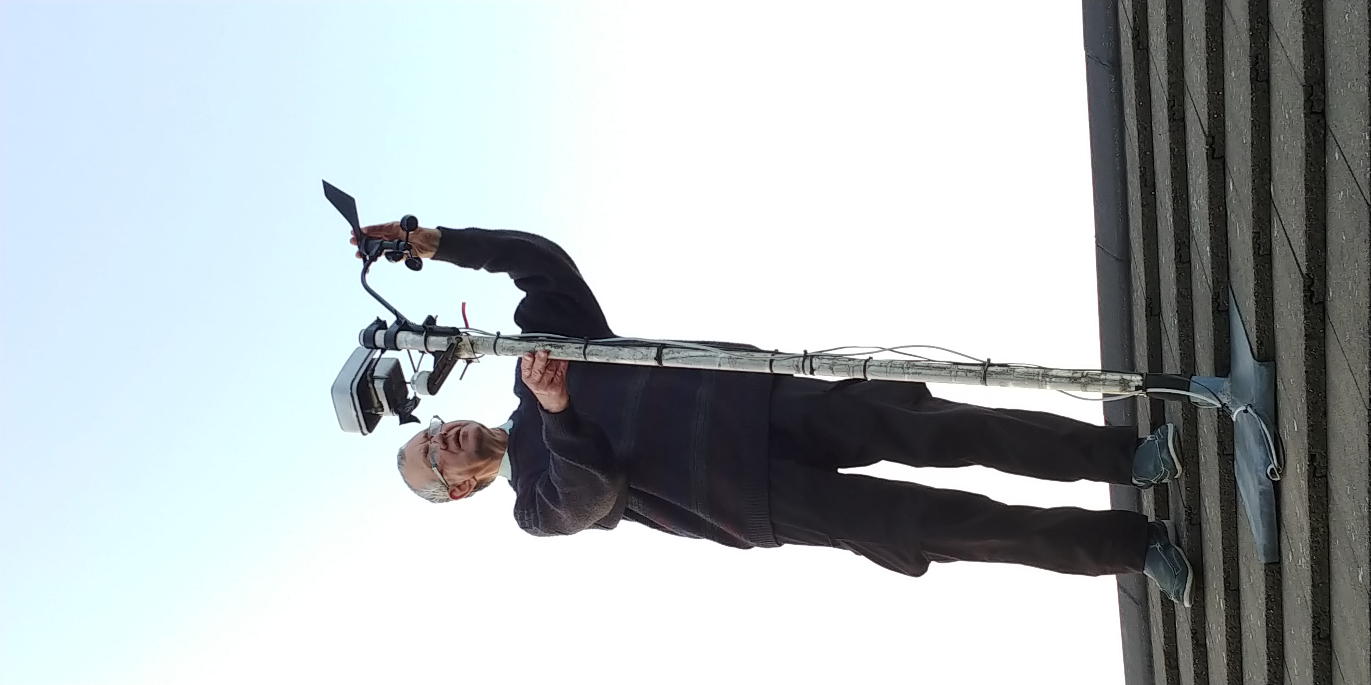
As well as my own
weather station in Harpur Hill in Buxton, at
www.buxtonweather.co.uk I am
proud to be a member of the Team of Volunteers, manning the Met
Office Climatological Station, on the Slopes, near the Crescent
in Buxton - would you like to know more about that weather
station? - what it does - and its incredible 150+ years history?
- If so please
CLICK HERE
|
Weather Links
Press here for
a ALMOST LIVE (Updated every 20 seconds) Video Webcam, looking west up the A54/ A537 Cat & Fiddle Road  on the A53 Leek Road, at the famous Winking Man Pub
CLICK HERE!
on the A53 Leek Road, at the famous Winking Man Pub
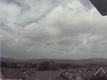
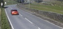
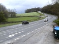
CLICK HERE! Like to see the weather at The Cat & Fiddle Pub (On the A537 Macclesfield Road) Height 518 Mts - CLICK HERE!  DCC Camera just near The Cat & Fiddle Pub (On the A537 Macclesfield Road) Height 518 Mts - CLICK HERE! 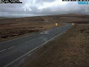 DCC Camera A515 Ashbourne Road near Hurdlow - CLICK HERE! 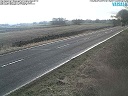 DCC Camera A623 at Tideswell Crossroads - CLICK HERE 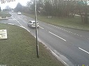 Like to see the weather at Flash Bar Stores Quarnford, near The Travellers Rest Pub, (On the A53 Leek Road) Height 469 Mts- CLICK HERE:!  Click below to a webcam at the HSL site, above Harpur Hill, Buxton - Location SK055705 - Height 390 Mts (Updated every 30 minutes) - CLICK HERE:! 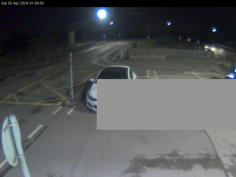 Like to see where the Jet Steam is RIGHT NOW? - Click Here 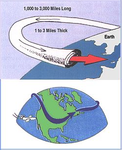
Like an explanation of how the Jet Stream affects our weather? - CLICK HERE LIGHTNING - Click Here to View Current Lightning Activity Over the UK 
Site and
Weather Station Maintained by Michael Hilton, Buxton, Derbyshire |
Conditions At: 21:12 on 2/8/26 |
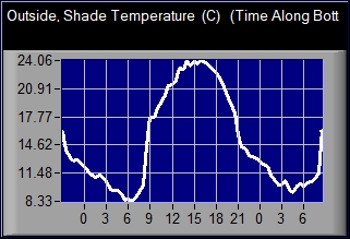
Outside, Shade Temperature 18.5 °C |
|
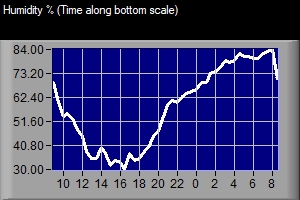
| Dew Point | 12.3°C | ||
| Humidity | 67% | ||
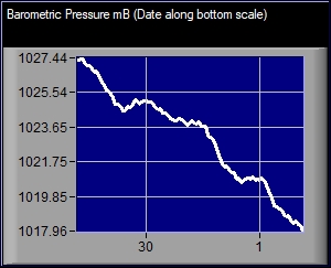
| Barometer (corrected to sea level) |
1016mB Rate 0.23mB/hr |
||
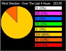
| Wind Figures: | |||
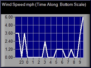
| Wind Speed | 0mph | ||
| Wind Direction | E | ||
| Wind Chill (How the temperature actually "feels") | 18.5 °C | ||
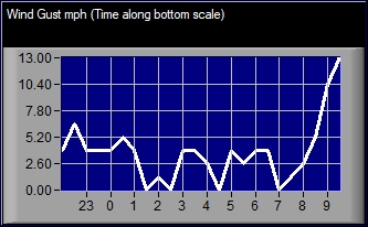
| Wind Currently Gusting To | 5mph | ||
| Peak Wind Gust Today | 14mph at 13:07 | ||
| Rainfall Figures: | |||
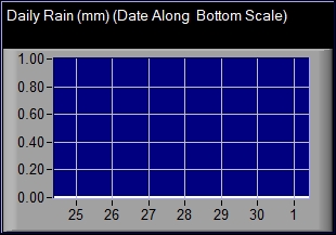
| Rainfall Today (Since Midnight) | 0.0 mm | ||
| Rainfall in the last hour | 0.0 mm | ||
| Total Rainfall in August | 0.0 mm | ||
| Total Rainfall in July | 20.4 mm (0.80 inches) | ||
| Total Rainfall in June | 118.4 mm (4.66 inches) | ||
| Total Rainfall in May | 92.2 mm (3.63 inches) | ||
| Total Rainfall in April | 34.6 mm (1.36 inches) | ||
| Total Rainfall in March | 115.6 mm (4.55 inches) | ||
| Total Rainfall in February | 194.6 mm (7.65 inches) | ||
| Total Rainfall in January | 173.6 mm (6.83 inches) | ||
| Total Rainfall in 2025 | 1319.4 mm (51.95 inches) | ||
| Total Rainfall in December | 192.0mm (7.56 inches) | ||
| Total Rainfall in November | 216.8mm (8.54 inches) | ||
| Total Rainfall in October | 189.2mm (7.45 inches) | ||
| Total Rainfall in September | 237.0mm (9.33 inches) | ||
| Total Rainfall in August | 44.2 mm (1.74 inches) | ||
| Total Rainfall in July | 66.8 mm (2.63 inches) | ||
| Total Rainfall in 2024 | 1549.8 mm (61.02 inches) | ||
| Total Rainfall in 2023 | 1787 .8 mm (70.39 inches) | ||
| Total Rainfall in 2022 | 1370.0 mm (53.94 inches) | ||
| Total Rainfall in 2021 | 1612.2 mm (63.48 inches) | ||
| Total Rainfall in 2020 | 1531.86 mm (60.31 inches) | ||
| Total Rainfall in 2019 | 1424.2 mm (56.07 inches) | ||
| Total Rainfall in 2018 | 1038.8 mm (40.90 inches) | ||
| Total Rainfall in 2017 | 1250.4 mm (49.23 inches) | ||
| Total Rainfall in 2016 | 1055.2 mm (41.54 inches) | ||
| Total Rainfall in 2015 | 1191.20 mm (46.90 inches) | ||
| Total Rainfall in 2014 (For earlier figures see the link top left) | 1245.60 mm (49.04 inches) | ||
| Sunshine Figures: | |||
| Sunshine hours on Saturday (Sunrise to Sunset) (Updated after Sunset) | 10. 51 Hours | ||
| Sun Hours in August (Updated after Sunset) | 10 . 51 Hours | ||
| Sun Hours in July | 249 . 06 Hours | ||
| Sun Hours in June | 174 . 81 Hours | ||
| Sun Hours in May | 185 . 08 Hours | ||
| Sun Hours in April | 206 . 10 Hours | ||
| Sun Hours in March | 122 . 98 Hours | ||
| Sun Hours in February | 29 . 25 Hours | ||
| Sun Hours in January | 32 . 13 Hours | ||
| Sun Hours in 2025 | 1502 .81 Hours | ||
| Sun Hours in December | 25 . 50 Hours | ||
| Sun Hours in November | 51 . 43 Hours | ||
| Sun Hours in October | 55 . 69 Hours | ||
| Sun Hours in September | 116 . 16 Hours | ||
| Sun Hours in August | 151 . 46 Hours | ||
| Sun Hours in July | 163 . 59 Hours | ||
| Sun Hours in 2023 | 1280 .03 Hours | ||
| Sun Hours in 2022 | 1414.14 Hours | ||
| Sun Hours in 2021 | 1242.25 Hours | ||
| Sun Hours in 2020 | 1330.53 Hours | ||
| Sun Hours in 2019 | 1316.47 Hours | ||
| Sun Hours in 2018 | 1431.27 Hours | ||
| Sun Hours in 2017 | 1096 . 00 Hours | ||
| Sun Hours in 2016 | 1219 . 59 Hours | ||
| Sun Hours in 2015 | 1239 . 88 Hours | ||
| Sun Hours in 2014(For earlier figures see the link top left) | 1226 . 69 Hours | ||
| Monthly Average Temperatures: | |||
| Average Temp in July | 17 . 65°C | ||
| Average Temp in June | 15 . 68°C | ||
| Average Temp in May | 12 . 12°C | ||
| Average Temp in April | 8 . 64°C | ||
| Average Temp in March | 6 . 63°C | ||
| Average Temp in February | 4 . 53°C | ||
| Average Temp in January | 2 . 71°C | ||
| Average Temp in 2025 | 9. 61 °C | ||
| Average Temp in December | 5 . 49°C | ||
| Average Temp in November | 6 . 57°C | ||
| Average Temp in October | 9 . 75°C | ||
| Average Temp in September | 11 . 91°C | ||
| Average Temp in August | 15 . 90°C | ||
| Average Temp in July | 16 . 36°C | ||
| Average Temp in June | 15 . 41°C | ||
| Average Temp in 2024 | 9. 32 °C | ||
| Average Temp in 2023 | 9. 52 °C | ||
| Average Temp in 2022 | 9. 63 °C | ||
| Average Temp in 2021 | 8. 66 °C | ||
| Average Temp in 2020 | 8. 93 °C | ||
| Average Temp in 2019 | 8. 65 °C | ||
| Average Temp in 2018 | 8. 87 °C | ||
| Average Temp in 2017 | 9. 60 °C | ||
| Average Temp in 2016 | 8. 95 °C | ||
| Average Temp in 2015 | 8. 54 °C | ||
| Average Temp in 2014 ( For earlier figures see the link top left) | 9. 24 °C | ||
| Today's Temperature Extremes: | |||
| High Temperature | 23.8°C at 16:05 | ||
| Low Temperature | 10.1°C at 3:33 | ||
| Other Extremes (Since March 2003) | |||
| High Temperature |
36.3°C at 15.02 on 19th July
2022 (Previous highs were 34.3°C at 17.13 on 18th July 2022 , 31.90°C on 25th July 2019 and 30.7°C at 15.51 on 9th August 2003) |
||
| Low Temperature |
-11.0°C at 07:35 on 20th December 2010 |
||
| Highest Daily Rainfall (Midnight to Midnight) |
79 mm (3.11 inches) on 20th October
2023 Previous highest was 77 mm (3.03 inches) on 10th August 2004 |
||
| Highest Monthly Rainfall |
308
mm (12.13 inches) in February 2020 (Previous highest was 287mm (11.30 inches)in August 2004) |
||
| Highest Daily Sunshine Hours |
16.50 Hours on 14th June 2023
Previous highest was 16.36 Hours on 27th June 2018 |
||
| Highest Monthly Sunshine Hours | 281. 87 Hours in July 2006 | ||
| Highest Wind Speed Gust | 88.08 mph on 21st January 2012 | ||
| Astronomical Data | |||
| Sunrise | 5:27 | ||
| Sunset | 21:02 | ||
|
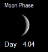
Moon Phase Indicator Below - Click on the icon for an explanation, and details of the moon's phases, and a calculator of the moon's phase on any day in history - or in the future! |
|||
|
|
|||
| Moonrise | 22:06 | ||
| Moonset | 9:53 | ||